Southern AZ, NM, TX, CO, WY, MT Tour
Extended road trip through the American West
20080801 to 20081005
Final update: 20081007
Back to Bill Caid's Home Page.
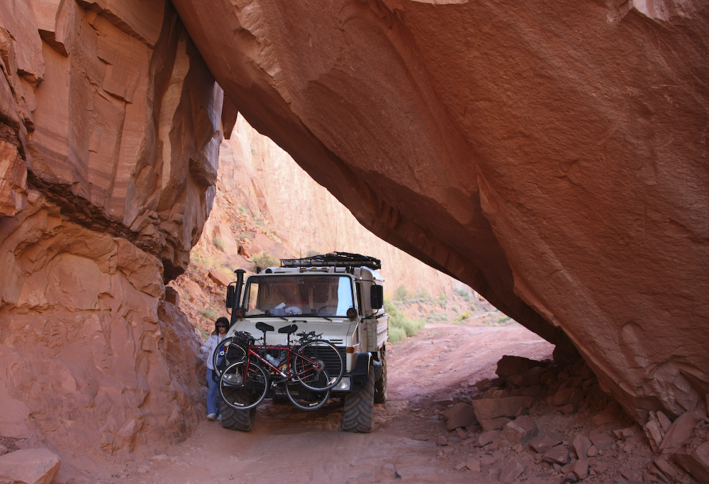
Kathleen prepares to spot me as we negotiate a fallen slab in Pucker Pass, Moab, UT. The height of the camper made it close.
Canon 1DsM3, 28mm (cropped), 1/60s at f/5 ISO 200. All photos copyright, Bill Caid 2008. All rights reserved.
New Capability - Track our current location!
After our mechanical issues that we suffered in southern Utah, we purchased a SPOT geo-location transmitter. This device reports your position through a satellite network and plots your path on Google maps. Additionally, the device has the ability to send messages through the satellite indicating that you are "OK", "Need assistance" or are having an emergency event. We hoped to not use the emergency capabilities of the device, but after the last trip, we felt that being prepared was the best solution. To follow our progress and see our current location in "near real time" see http://share.findmespot.com/shared/faces/viewspots.jsp?glId=0W876btSW8SH7xrG6Z70n0NhXS9sne7me Bookmark this location to see our position over time. It shows the last 50 positions. NOTE: since this trip is completed, the display will likely be uninteresting since the truck is parked in the driveway.
Exploring the Southwest
Most of the American west is arid at one level or another. I have lived the majority of my life in the west, but in actuality, have seen a relatively small part of the area. Over the years, I have attempted to travel to new areas when I could to explore these new regions and learn about the geography, flora and fauna. Kathleen and I have gone to the desert many times through the years, but had never attempted to travel to the area to the east of my birth city of Tucson, AZ. Since we repaired the transmission damage and added a few features to the Unimog, we decided to pack up and head east. Unlike some of the other trips that we have made, this one was planned to be mostly on the road. Not because we did not want to do dirt roads, but rather due to the extreme distances that were required and the times required, the highway was the only alternative.
Exploring the west requires planning particularly with respect to fuel. Our planned route did not take us too far from civilization, but caution is always required. Additionally, since our route would take us into the back country near the border, extra care was given to "security concerns".
Since both Kathleen and I were between jobs, we decided to make the best use of our time. Sadly, choosing to go when we did caused us to suffer a big heat wave. Temperatures in Arizona were near 115 degrees causing substantial stress on both man and machine. We had a number of heat-related failures but in the end we prevailed. The weather provided challenges in other ways as well. We suffered rain on nearly every day since the trip was during the monsoon season. On one night in particular, the thunderstorms were heavy enough to provide near-flood conditions requiring us to prepare for an evacuation on short notice. Happily, the waters receded before action was required.
The Team and Equipment
The away team for this trip consisted of only one vehicle and 2 folks. Kathleen and I went in our turbo-diesel Mercedes Unimog 1300L with our now-proven Alaskan camper. We would have loved to go with another vehicle, but this was planned to be an extended duration trip and therefore would have been a great imposition on any partners who had "real" jobs.
With the recent completion of our camper for our Unimog, we now had a vehicle that would allow us to travel great distances to remote regions in relative comfort. Given our ability to carry water and fuel and the general remoteness of the region, we were limited to about 4 days maximum between re-supply points. Food was not an issue since we could always eat canned food, but access to water was the limiting factor.
The Trip
I was born and raised in the Tucson area and am very familiar with that area. But, despite spending many years there, I had never been to southeastern Arizona and the area around Sierra Vista, Bisbee and Douglas. Furthermore, despite going to military school in Roswell, NM, I never had a chance to explore southern New Mexico.
Our plan was to head from San Diego, CA to Tucson, then south to the area around Benson,AZ to see Karchner Caverns. From the cave, we would head to the south east along the Mexican border, then east past El Paso, TX. Our goal was to visit Carlsbad Caverns. After Carlsbad, we planned to head north toward Santa Fe and into the Sangre de Christo range for some back country work. After northern NM, we planned to visit Colorado, then return to San Diego through Utah and northern Arizona.
We were anxious to complete the balance of our mechanical-issue-shortened trip to Utah. We planned to visit the area around Blanding called "Beef Basin" and "Ruin Park". While it would still be hot, it would be nowhere as hot as the 115 degrees we withstood in southern Arizona.
Trip Details
The link table below contains links to the daily adventures that include photos and dialog about what we saw.
Conclusion
The west is much bigger than you think. You can look at the map and compute mileages, but until you actually are there and drive the roads and trails, you cannot fully appreciate the scope of the area. Southern Arizona and New Mexico have vast areas of unremarkable desert punctuated with interesting mountains. As we traveled north, we encountered dramatic changes in weather running from over one hundred degrees during the day to nearly freezing at night.
Our trip lasted 66 days and spanned about 8,000 miles. I really do not know how far we traveled as my odometer broke about half way through. But, I do know the fuel consumption and with 800 gallons consumed it equals about 8,000 miles.
I could have done without the mechanical failures, but my rig is 30 years old. Stuff happens. The good news is that none of the failures were that severe that they could not be fixed. Clearly, the hub was a major failure. But in the end, I repaired it myself, with a little help from my friends.
Traveler's Advice
This trip offered a multitude of challenges, some unanticipated. The mileages that must be traversed in this region are large and it is not uncommon to go over 100 miles between fuel stops. Some small towns have gas, but not diesel. Some towns have both. Cell service is spotty in most of the region and totally non-existent in back country regions. If you go, you should make appropriate plans for communications including a CB radio and/or 2 meter ham radio that will allow you to call for help should that be required. If you have the funds, you may want to consider a satellite phone as a communication alternative.
Ice is generally available in most towns. Water, in small quantities such as bottled water is also easily available. Water in larger quantities, such as filling your tanks in your RV can be found in most organized camp grounds and waste dump stations.
If you have an unusual vehicle, like say a Unimog 1300L, you may want to consider bringing spare parts. Stuff happens. I used both fuel filters and my oil filter on this trip. I did not have access to the bearings, gears, seals and case that failed when the hub went out, but I was lucky that they were shipped to me. I will not make that mistake again and will carry a full bearing set with me on future expeditions. Also, I should have brought the service manual with me, but did not. Luckily, we had an internet connection and my friends were able to email photos of the relevant pages allowing me to do the repair myself.
Miscellaneous Information
We experienced a wide range of fuel prices. The highest was $4.85 and the lowest was $3.66 a gallon for diesel. You should factor this into your trip budget. Also, we were unable to purchase diesel in one city as the tanker truck did not come. We had fuel cans, will you?
Back to Bill Caid's Home Page.
Copyright Bill Caid 2008