Lower Colorado, Mojave and Great Basin Desert Adventure
Extended road trip through the desert Southwest
20080330 to 20080410
Back to Bill Caid's Home Page.
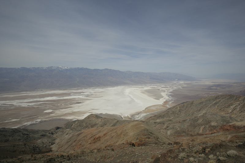
Death Valley as seen from Dante's View.
Canon 1DsM2, 16mm, 1/400 at f/10 ISO 100. All photos copyright, Bill Caid 2008. All rights reserved.
Exploring the Desert Southwest
Most of the American west is arid at one level or another. I have lived the majority of my life in the west, but in actuality, have seen a relatively small part of the area. Over the years, I have attempted to travel to new areas when I could to explore these new regions and learn about the geography, flora and fauna. Kathleen and I have gone to the desert many times through the years, but had never attempted to travel to the area around Death Valley and the Great Basin region of Nevada. So, armed with some preliminary knowledge of some "good" places to see and the knowledge that the distances were great and substantial travel time would be needed to pull this off, we loaded our truck and headed out.
Exploring the west requires planning. Distances are large and many small towns do not have any form of accommodations including stores that sell food. In fact, when we were at Baker, NV (the town closest to Great Basin NP), one of the rangers stated that when she wanted to go shopping, she had to drive to Salt Lake City, a distance of several hundred miles one way! Indeed, many towns we passed through had minimal supplies and great areas were without cell service. Generally speaking, if you go, you must assume that you have to be "self contained" in all respects: food, water and fuel. And, you must have the ability to make minor repairs unassisted should the need occur. The distances involved are substantial and the roads are not heavily traveled. In one section of Highway 6 in central Nevada, we traveled several hours and did not see another vehicle, either oncoming or passing. If you break down here, you had better be prepared.
In addition to diverse geology, the region has diverse weather as well. In the course of one day, we went from snow to blowing dust to heat. You must be prepared for radical changes in the weather. We were confronted with below freezing temperatures and mid-nineties heat in the course of 2 days.
The Team and Equipment
The away team for this trip consisted of only one vehicle and 2 folks. Kathleen and I went in our turbo-diesel Mercedes Unimog 1300L with "new" Alaskan camper. Given where we intended to go and the general remoteness of the area, we should have gone with another vehicle "just in case", but we went alone anyway.
With the recent completion of our camper for our Unimog, we now had a vehicle that would allow us to travel great distances to remote regions in relative comfort. Given our ability to carry water and fuel and the general remoteness of the region, we were limited to about 4 days maximum between re-supply points. Food was not an issue since we could always eat canned food, but access to water was the limiting factor
The Trip
I had long wanted to explore Death Valley and the surrounding areas. Conversations with a close friend, Mark Mitchell, convinced me that the area was "rich" enough in potential adventure to go and go soon. We started watching the weather in January, 2008 and for a variety of reasons, including a death in the family, the trip continued getting delayed. Finally, in late March, the stars aligned and allocated a week to do our trip. As fate would have it, a week was not enough. About half way through, we concluded that we would extend the trip and just "go with the flow".
Our trip to the western deserts lasted nearly 2 weeks and would encompass a good chunk of Southern California and Nevada. We traveled from Borrego Springs, CA all the way to Ely, NV passing Joshua Tree NP, the Mojave Preserve, Death Valley and the Great Basin NP along the way. The entire path would take us over 1,500 miles across the desert west.
Our plan was to head from the San Diego, CA area, through the Lower Colorado desert regions near Borrego Springs, though the Imperial Valley to the Mud Hills near Mecca, CA. From there, we would head north through Joshua Tree, then through the Mojave Preserve and into Death Valley. We planned to spend several days exploring the sights in Death Valley and then head east into the Great Basin desert and essentially cross the entire state of Nevada. From our terminal point at the Great Basin National Park, we would then work our way south back to San Diego.
Geography of the Western Deserts
A big portion of the American west is desert of one form or another. Geologists have carved the west into 5 or 6 separate "kinds" of desert regions including the Sonoran, Chihuahuan, Lower Colorado, Mojave and Great Basin deserts. Each of these areas have different physical areas, altitudes, soil types and temperatures. They all share one common attribute and that is the lack of water. Our trip took us through all of these deserts except the Chihauhan region and we experienced all kinds of weather from hot and sunny to cold, wind and snow.
I tried to find a satellite photo of the area, but as of the publication date of this page was unsuccessful.
Trip Details
The link table below contains links to the daily adventures that include photos and dialog about what we saw.
| Day | Date | Adventure |
|---|---|---|
1 |
20080330 |
Borrego Springs and Hawk Canyon |
2 |
20080331 |
Mecca Mud Hills and Ladder Canyon |
3 |
20080401 |
Joshua Tree National Park, Mojave Preserve and Providence Mtns. |
4 |
20080402 |
Death Valley: Butte Valley and Willow Springs |
5 |
20080403 |
Death Valley: Mengel Pass and Aguereberry Point |
6 |
20080404 |
Death Valley: Dante's View |
7 |
20080405 |
Death Valley: Scotty's Castle, Ubehebe Crater and Eureka Sand Dunes |
8 |
20080406 |
Death Valley: Steele Pass and Saline Hot Springs |
9 |
20080407 |
Death Valley: Saline Valley to Beatty, NV |
10 |
20080408 |
Beatty, NV to Great Basin National Park |
11 |
20080409 |
Lehman Cave and Cathedral Gorge |
12 |
20080410 |
Cathedral Gorge to Las Vegas |
Conclusion
Traveler's Advice
This trip offered a multitude of challenges, some unanticipated. The mileages that must be traversed in this region are large and it is not uncommon to go over 100 miles between fuel stops. Some small towns have gas, but not diesel. Some towns have both. Cell service is spotty in most of the region and totally non-existent in back country regions. If you go, you should make appropriate plans for communications including a CB radio and/or 2 meter ham radio that will allow you to call for help should that be required. If you have the funds, you may want to consider a satellite phone as a communication alternative.
Ice is generally available in most towns. Water, in small quantities such as bottled water is also easily available. Water is larger quantities, such as filling your tanks in your RV can be found in most organized camp grounds and waste dump stations.
Miscellaneous Information
Back to Bill Caid's Home Page.
Copyright Bill Caid 2008