Trip Report: November 1-8, 2002
Northwestern Sonora in Mexico is one of the largest remaining remote areas south of Canada. This area is hard core desert, cruel in the summer and unforgiving of mistakes. Four wheel drive clubs in the southwest have been making crossing of the Altar Dunes from either the Sonoita area or from San Luis del Colorado south of Yuma, AZ. for many years. This area offers one of the last remaining true adventures within easy driving distance from the US. I had done this trip in 2000 with the same crew, so we had good knowledge of the rigors that faced us. Indeed, the Altar is a test of man and machine as well as your logistical planning skills.
Once in Rocky Point, we would refuel, re-ice and buy camarones (shrimp), almejas (clams) and then find a suitable camping spot on the Sea of Cortez. See the satellite photos and maps lower on this page.
Given the time requirements to make this long crossing, substantial pre-planning was required. To do such a trip required detailed knowledge of what conditions were expected as well as research on issues beyond just road conditions. To prepare for this trip, we utilized experience gained from the previous trip, tide charts, satellite photos, Mexican maps as well as other intelligence gathered from the local four wheel clubs. As we will see later, knowledge of the tides was of critical importance given that we intended to travel on the beach and could become trapped against the cliffs if the tide turned against us.
To insure the success of a major expedition in a foreign country, it is absolutely essential that the proper team of vehicles and operators was assembled. Of key importance was vehicle reliability. The size of the Altar dunes basically precludes the ability to tow a truck as dead weight. While theoretically possible, the time required to complete the winching make recovery a practical impossibility. Therefore, special attention was given to mechanical preparations prior to the trip. And, in general, this paid off in a relatively trouble-free trip, tire issues notwithstanding.
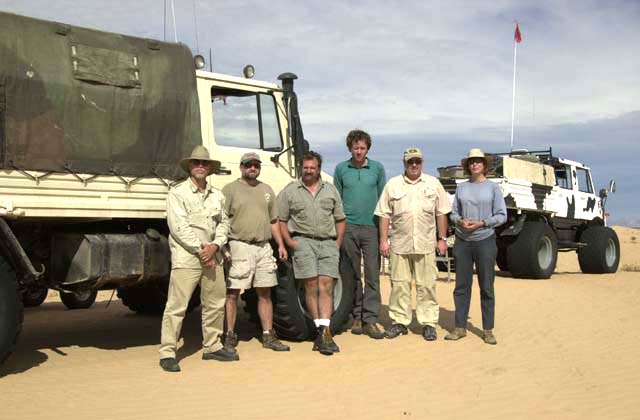
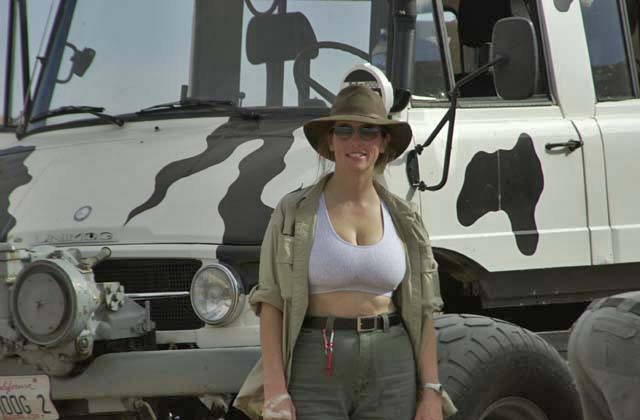
From Left to right are: Bill Caid (San Diego), Scott Clements (Indiana), Kai Serrano (San Diego), Matt Oliphant (Los Angeles), Dan Johnson (Indiana) and Nancy Oliphant (San Diego). Below, is Kathleen Jones (San Diego), the resident self-appointed "trail dominatrix".
All drivers had substantial experience in hard-core off-roading. All had completed the Rubicon and all the hardest trails in Moab. Additionally, this group had previously successfully done the high dunes of the Altar Desert in 2000 and lived to tell about it.
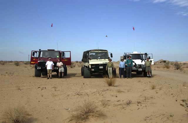
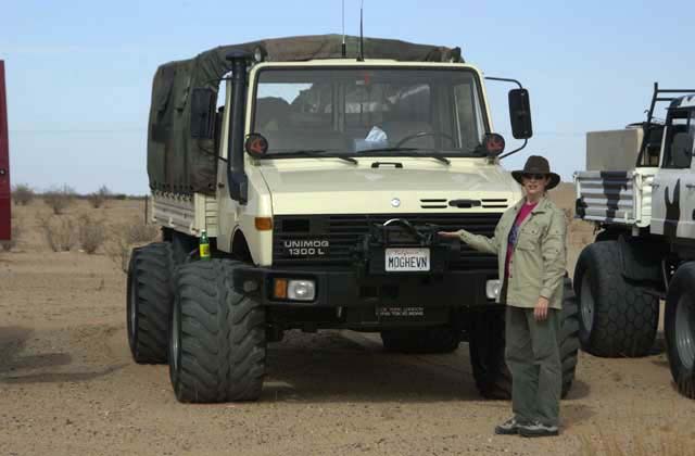
| Bill Caid and Kathleen Jones from San Diego were in Caid's 1979 U1300L (435 single cab) with 1987 Yamaha Banshee ATV. | |
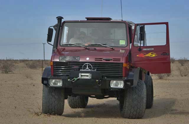
| Dan Johnson and Scott Clements from Indiana were in Dan's super clean, tricked out 1992 U1550L (435 single cab). | |
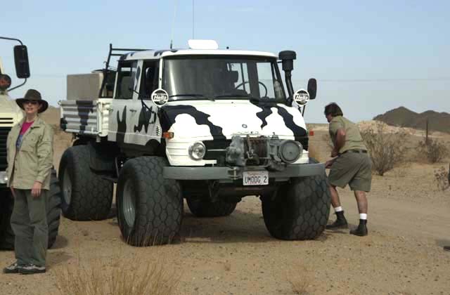
| Kai Serrano, Matt and Nancy Oliphant from San Diego and LA respectively were in Kai's 1978 U900 (416 double cab). |
A comparative shot of all three vehicles is below.
.
Photos of the individual rigs are below. First, the 1300L with Kathleen doing a reasonable Vanna White impression. For this trip, I purchased a used set of Goodyear 24x20 Terra Tires and custom rims to help negotiate the soft sand. As a "side benefit" the tires increased the track width to about 9 feet, giving good stability on side hills.
Next is the 1550L with some magnetic flames for that extra speed. Given that the 1550 has the OM366 motor, the flames were justified. Dan is running the 22x20 Continental sand service tires on stock Unimog rims. His rig, in addition to a spare fuel tank, also has central tire inflation which was as much of a hindrance as it was a help.
Kai's 416 cow mog was fully loaded with camping equipment and equipped with Continental 22x20 sand service tires. These tires were purchased used and was the only set that did not give us problems. Also, for we got to use the winch several times as both he and Dan got stuck in the mud near the water's edge.
In Figure 1, San Diego bay is just below the top edge on the left. The large lake is the Salton Sea. Farmed areas are shown in red. The road in Mexico that parallels the border can be seen. Refer to the map below for reference.
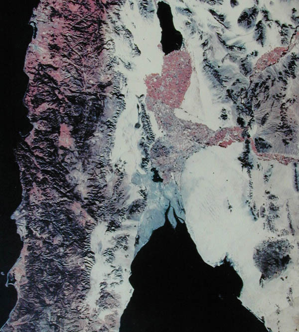
Figure 1. Satellite Photo of Northern Baja and Northwest Sonora, Mexico.
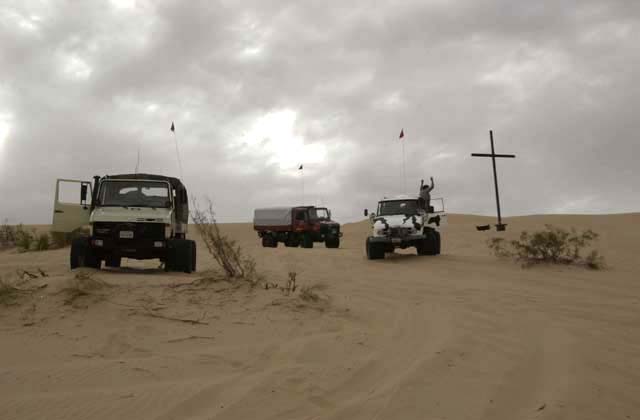
In Figure 2, the large dunes are evident and can be seen as forming a set that roughly parallel the coast to the south. The destination was El Gulfo de Santa Clara, and this is due east of the end of the largest "gray colored" island at the mouth of the Colorado River.
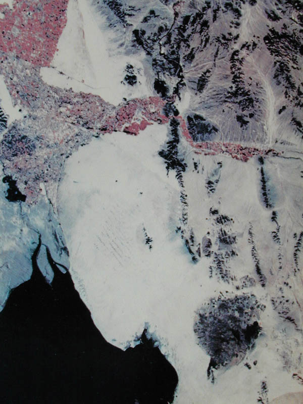
Figure 2. Zoom Photograph of Area of Interest.
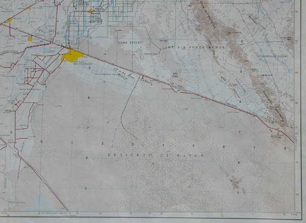
Figure 3. Map of the Northern Portion of the Trip.
Figure 4. below shows the southern portion of the trip. Click on the map to get a full resolution view. This is a 300kb file, so if you have a phone modem, this will take a while to load. The parallel lines are 10km marks, so distances can be estimated from them.
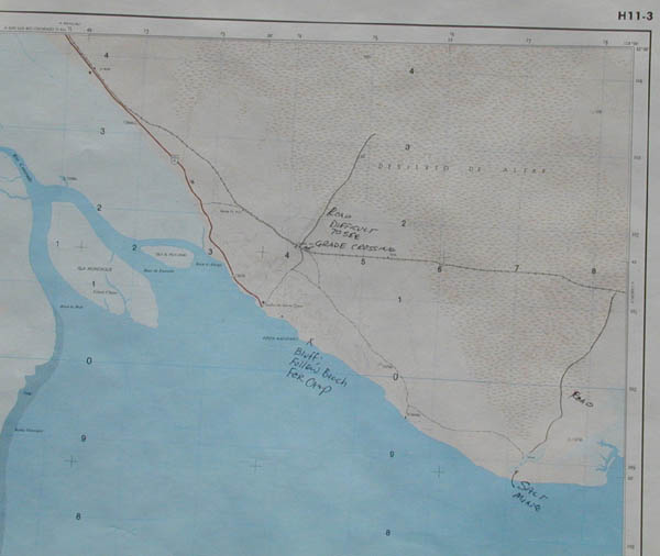
Figure 4. Map of the Southern Portion of the Trip.
On this trip, I never did get a good estimate of mileage. When I looked at the odometer, it was on either day 2 or day 3. When left the dunes, given that reading, we had traversed nearly 300 miles of territory. Total fuel usage for my 1300 was about 130 gallons border to border. I only took on fuel in Puerto Penasco as El Gulfo was out of diesel (again).
For those readers that are technically minded, the table below contains the UTM coordinates of our camp sites. The datum is NAD-27.
|
Description |
Zone |
East Coordinate |
North Coordinate |
| Start at Cesar's | 11 | 735656E | 3586700N |
| Goal | 12 | 239566E | 3515816N |
| Camp 02-11-2002 | 11 | 736003E | 3566682N |
| Camp 03-11-2002 | 11 | 756691E | 3542520N |
| Camp 04-11-2002 | 12 | 216648E | 3528128N |
| Camp 05-11-2002 | 12 | 249989E | 3484091N |
| Camp 06-11-2002 | 12 | 249989E | 3484091N |
| Camp 07-11-2002 | 11 | 727100E | 3539822N |
| End | 11 | 735656E | 3586700N |
Day 0: 01-11-2002 Getting to Yuma and the trail head
Day 1: 02-11-2002 Leaving for Sonora
Day 2: 03-11-2002 The Cross to Camp Sidewinder
Day 3: 04-11-2002 Camp Sidewinder to Camp Scorpion
Day 4: 05-11-2002 Beach Rescues and Other Follies
Day 5: 06-11-2002 Visit to Puerto Penasco
Day 6: 07-11-2002 Encounter in the High Dunes
Day 7: 08-11-2002 Return to the USA
El Gulfo is a very small town; this is primarily a fishing village, but does cater to tourists, particularly Gringos around Thanksgiving, Christmas and New Years. There is a Pemex station, and it probably has gas. I say probably, because in Mexico, if the fuel truck does not show up for what ever reason, then there will be no gas. There is a store and ice is available along with plenty of fresh fish, shrimp, clams and sometimes other shellfish. Water is in short supply, but can be purchased at the town store. There are several RV parks in town and several "hotels". The quotes are used here since one of the selling features of the hotel is that it has indoor plumbing.
The locals make their living fishing, and good seafood is available at all times. The best restaurant in town is the El Delfin and has excellent food.
Firearms are prohibited in Mexico. Handguns, in particular, are frowned upon. If you are caught with one in your possession, you will go directly to jail. There is a very high likelihood that you will be unable to "buy" your way out of the situation no matter how much money you have with you, so this situation is better avoided. While lack of a firearm in the wilderness will place you at somewhat of a disadvantage should trouble arise, the penalty for possession is so harsh that it is not worth the risk. The proposed area of operations is known to be used by drug smugglers. However, the open desert crossing is not the preferred route, so the chance of encountering anyone is nil. But, the Mexican Army does patrol both the north end and the sea-side of the desert and if they stop you, they will most likely do a thorough search of the vehicle. They pose no threat to honest Gringos that do not break the laws of their country.